21.3°
Thunderstorm
Feels like 25°
Updated Thu 15 Oct 2026 3:10 pm AEST
Severe Weather Warning
Issued at 2:47 pm Thursday, 15 October 2026.
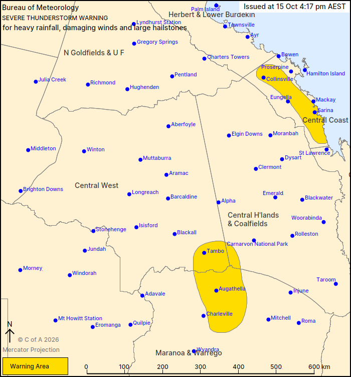
Warning Map
A stalling trough about the southern Central Coast & Whitsundays district is resulting in an increase in showers and weather conditions through the region with locally heavy rainfall developing.

Severe weather conditions are likely to produce heavy rainfall that may lead to flash flooding in the warning area over the next several hours. Locations which may be affected include Sarina.

The next warning is due to be issued by 5:50 pm.

Min Temp
21.3°
at 2:50pm
Max Temp
30.1°
at 12:12pm
10-min Avg. Wind
8 km/h
SSW
Gusting
13 km/h
Max: 35 km/h at 1:02pm
Rainfall
20.0 mm
since 9am
Humidity
96 %
Dew Point: 20.7°
Lightning Strikes
⚡️ 2
detected today
Recent Lightning
9 km
SSW at 3:05:29 pm
Eton Forecast
Thursday 15 Oct
MIN
20°
MAX
30°
Rest of Today
Showers at times during the day, with a chance of thunderstorms. Easterlies.
Tonight
Showers at times overnight with a low chance of a thunderstorm. A slight chance of fog patches.
Rainfall 8-35 mm
Rain 80%
Wind E 20-30
Dew Pt 21°
Overnight Morning Afternoon Evening
↑ Sunrise 5:31 am
↓ Sunset 6:06 pm
Current Skycam
Recent Skycam Images
4 AM
6 AM
8 AM
10 AM
12 PM
2 PM
7-Day Observations
Menu Home Forecast Radar Observations
Enlarged warning map
Loaded successfully via ASPGWeather.com's Canberra server through Cloudflare (CMH edge) at 4:11:21pm AEDT on Thursday 15/10/2026. Rendered in 20 ms · Encrypted (HTTPS) · Visitor region US · Ray a4ac52943ec24b2a-CMH